+86 15898932201
Monitoring Sediment in Runoff Water system is specifically designed for the automatic monitoring and assessment of soil erosion. It automatically measures key parameters such as runoff volume, sediment concentration, total runoff, and cumulative rainfall. It can be adapted for installation in standard runoff plots with varying slopes, providing quantitative data for soil and water conservation research.
Monitoring Sediment in Runoff Water is a professional instrument for the quantitative and automated collection of soil erosion process data. Its core objective is to replace traditional manual observation methods, obtaining precise information on runoff and sediment carried by runoff under natural or simulated rainfall conditions through continuous automatic measurement. This allows for a scientific assessment of soil erosion intensity and the effectiveness of soil and water conservation measures.
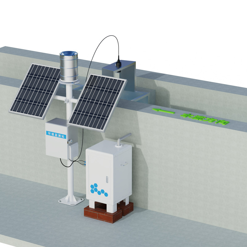
The system is primarily deployed in standard runoff plots. A runoff plot is a rectangular slope area with defined boundaries, specific slope, vegetation, and soil treatment. The main part of the equipment is installed at the lower end of the plot, receiving and measuring the water-sediment mixture flowing from the entire plot surface.
The system's working principle is based on multi-sensor integration and automatic control. The basic workflow is as follows: When rainfall generates surface runoff, the water mixed with sediment flows from the runoff plot outlet through a diversion channel into the measurement system. First, the system measures the instantaneous runoff volume using a tipping bucket or turbine flow sensor and calculates the total runoff volume. Simultaneously, the system uses a sediment concentration sensor (such as an optical turbidity sensor or an ultrasonic attenuation sensor) to monitor the sediment concentration in the runoff in real time. Combining the runoff volume data, the system automatically calculates the total soil loss for each rainfall event or specific time period. In addition, the equipment usually integrates or connects a tipping bucket rain gauge to synchronously record the rainfall process and cumulative rainfall, establishing the relationship between rainfall, runoff, and sediment yield.
A key technical feature is its adaptability to different slope conditions. The equipment's design allows its mounting base to be adjusted according to the actual slope of the runoff plot, ensuring that the diversion channel and collection device remain horizontal or at a preset angle. This ensures that the water flows smoothly into the measurement unit, avoiding water splashing or sediment deposition caused by slope differences, and guaranteeing the representativeness and accuracy of the measurement results. For steep slopes, the equipment structure is appropriately reinforced. The system typically includes data acquisition and remote transmission modules. The data acquisition unit controls all sensors to operate at a set frequency and stores the measured data. The data can be transmitted wirelessly to researchers' computers or cloud platforms, enabling remote real-time monitoring and downloading. This significantly reduces the labor costs of field data collection and allows for continuous recording of sudden erosion events such as heavy rainfall.
The data obtained from this device has clear scientific and practical value. Continuous runoff and sediment concentration time series can reveal the dynamic patterns of soil erosion and identify critical periods of runoff and sediment production. By comparing monitoring data from runoff plots under different vegetation cover, tillage methods, or engineering measures, the effectiveness of various soil and water conservation techniques in reducing runoff and sediment can be quantitatively evaluated. This data forms the basis for constructing and validating soil erosion prediction models and provides direct field observation data for regional soil erosion surveys, ecological project evaluations, and the formulation of relevant regulations and policies.
The normal operation of the equipment requires adherence to standardized installation and maintenance procedures. During installation, it is crucial to ensure a good seal with the runoff plot boundaries to prevent lateral seepage. During use, it is necessary to regularly clean contaminants from the sensor surfaces, calibrate the rain gauge and sediment concentration sensor, and check that the drainage channels are unobstructed, especially after heavy rainfall or high-sediment flow events.
Overall, the Monitoring Sediment in Runoff Water system transforms complex slope soil erosion processes into a series of analyzable time-series data through automated, high-frequency synchronous measurements. It has become an indispensable tool in modern soil and water conservation scientific research and monitoring, providing solid data support for a deeper understanding of soil erosion mechanisms, accurate quantification of erosion rates, and scientific prevention and control of soil erosion.
Article address:https://www.sqqx.net/en/news/812.html